The game
The battle. You hold a card face up; the cpu holds one face
down. Pick the stat you think wins; the cards compare, and the round
goes to the better number. First to three rounds takes the match. A
dead heat scores nobody. The battle runs on the SCALE set.
The ranks. Every stat’s full leaderboard, one stat
at a time, with the same per-stat rank chips the cards wear. There is
no combined score and no best metro.
The daily. One question a day, one guess, and a streak that
lives in your browser. Some days it is a head-to-head between two
close systems (never a blowout); some days you pick the right number
from four, where the wrong three are other cities’ real
figures. Your guess and streak never leave this browser.
Win directions are fixed. Opened and base fare win smaller;
everything else wins larger.
SCALE: the six
| stat | what it measures | wins |
|---|
| opened | earliest passenger service within the
card’s declared scope, the system’s own inaugural dating
(where first public access came later, the almanac notes it), from
Wikipedia and operator histories | earlier |
| stations | station complexes counted from the frozen
snapshot: named stations, same-name platforms merged within 350 m,
interchanges counted once. This plotted count runs a little above
operators’ official station tallies (long interchange corridors
are not always merged into one); the method is uniform across all 18,
so the comparison stays fair | more |
| span | the furthest-stations distance: the geodesic
between the two stations farthest apart | more |
| density | stations per square km of network extent,
the convex hull of the counted stations | more |
| route-km | reported route length, dated and sourced
(almanac grade) | more |
| ridership | reported annual rides, dated and sourced
(almanac grade) | more |
CHARACTER: the five
Every figure is dated; sources are in the
almanac file in the site’s public repo.
| stat | what it measures | wins |
|---|
| base fare | the adult single minimum fare, converted to
USD at one dated FX snapshot (2026-06-12) for every card, so
the row compares on one rate; check the operator for today’s
fare | cheaper |
| driverless | count of GoA3+ lines (driverless, attended
or not) within the card’s declared scope, from Wikipedia’s
driverless-train-systems list | more |
| transfer | share of the card’s station
complexes served by two or more counted lines, computed from our
own snapshot | more |
| biggest hub | the most counted lines that meet at a
single station complex, computed from the same snapshot |
more |
| new lines | lines that opened in the last decade (since
2016), counted from the per-line opening years | more |
Transfer and biggest hub are both computed from the same
snapshot as the other geometry stats. New York reads high on both
because its lettered and numbered services share track through most
stations, so a single complex counts many services. The cut stats
(peak headway, service hours, farebox recovery) were dropped for want
of one comparable, current source across the deck.
Scope: what each card counts
Each card declares its scope as the network its city’s own
familiar map draws as coequal metro lines: the rider’s
network, not one operator’s books. Modes the map itself marks as
distinct products (commuter overlays, trams, feeders, people-movers)
stay out. Frozen per city 2026-06-12 (D25):
| tokyo | Tokyo Metro + Toei only; through-running truncated at the scope boundary (the familiar Tokyo Subway map stops there). |
| seoul | The full capital-region network the familiar map draws, incl. Line 1's long Korail corridors, the K-lines, GTX-A, AREX, the light metros, Incheon 1-2 and Sinbundang (whose validator export is empty, so it rides from a committed OpenStreetMap supplement, fetched 2026-06-12). |
| singapore | MRT lines only; the LRT feeders are a distinct product on the LTA map. |
| hong kong | MTR heavy rail incl. the East Rail and Tuen Ma lines, the Airport Express and the Disneyland Resort line; Light Rail is the map's district inset, not the metro. East Rail carries the scope's earliest passenger service, 1910, which sets the opened year. |
| paris | Métro 1-14 plus 3bis and 7bis; RER excluded (it is not the Métro map). |
| shanghai | Metro lines 1-18 plus the Pujiang line; the maglev is a separate product even on the official map. |
| beijing | The full mapped network (run by several operators): 19 numbered lines, the named suburban lines, S1, Xijiao and both airport expresses; Batong rides as Line 1 and Daxing as Line 4, as the map draws them. |
| london | Underground's 11 lines only; the Elizabeth line, Overground and DLR are distinct products in the Tube map's own grammar. |
| new york | Subway services only; rush-hour diamond variants fold into their base service, the three S shuttles ride as one pill, and Staten Island Railway and PATH are separate systems. |
| madrid | Metro de Madrid lines 1-12 plus the Ramal; Metro Ligero is its own product on the map. |
| moscow | Metro lines incl. the MCC ring (the map's line 14); the D-branded MCD diameters are commuter rail, excluded. |
| copenhagen | Metro M1-M4 only; S-tog is a distinct product. |
| delhi | The DMRC network incl. the Airport Express; Rapid Metro Gurgaon and the Aqua line are separate concessions. |
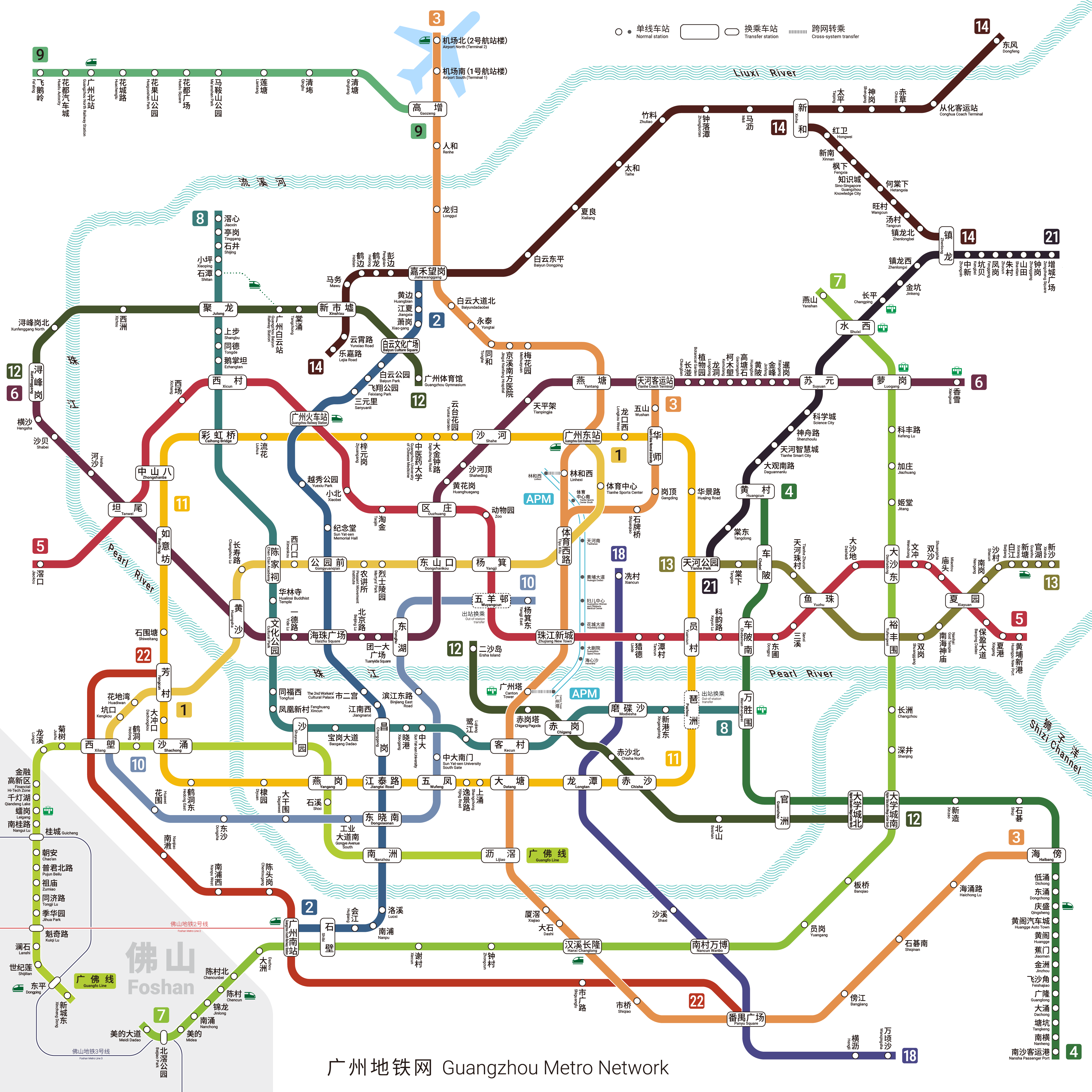
| guangzhou | Guangzhou Metro incl. the Guangfo through-line and the APM; Foshan Metro's own lines and the trams are distinct systems. |
| mexico city | The STC Metro's 12 lines; Tren Ligero and the Suburbano are separate systems. |
| cairo | Metro lines 1-3; the LRT and the monorail are separate systems. |
| osaka | Osaka Metro's nine lines incl. the New Tram (a coequal line on the map); the JR Loop and the Osaka Monorail are distinct products. Midosuji's through-run to Minoo-kayano is drawn continuous, so it stays; Kintetsu and Hankyu through-running truncates at the boundary. |
| istanbul | The branded Metro Istanbul M-lines (M1A and M1B fold to M1). Marmaray is TCDD commuter rail, excluded like Moscow's MCD; the funiculars and trams are separate feeder products. |
Sources and dates
Geometry, station counts, span and density: OpenStreetMap via the
subway preprocessor CDN, snapshot 2026-06-12, ODbL. The page is
built offline from committed snapshots; raw GeoJSON never ships.
Opened years: Wikipedia and operator histories, per-line, dated
(sources in the almanac file in the site’s public repo). Reported
figures:
| city | route-km | annual rides |
|---|
| tokyo | 304 km as of 2026 jametro.or.jp | 3,460 M FY2024 tokyometro.jp |
| seoul | 1,302 km as of 2026 en.wikipedia.org | 4,420 M 2024 railstat.korail.com |
| singapore | 243 km as of 2026 en.wikipedia.org | 1,249 M 2024 lta.gov.sg |
| hong kong | 271 km as of 2026-06-13 en.wikipedia.org | 1,714 M 2025 mtr.com.hk |
| paris | 246 km as of 2024 en.wikipedia.org | 1,476 M 2024 en.wikipedia.org |
| shanghai | 816 km as of 2026 en.wikipedia.org | 3,661 M 2023 en.wikipedia.org |
| beijing | 909 km as of 2026-06 en.wikipedia.org | 3,450 M 2023 en.wikipedia.org |
| london | 402 km as of 2026 en.wikipedia.org | 1,181 M 2023/24 en.wikipedia.org |
| new york | 399 km as of 2026 en.wikipedia.org | 1,300 M 2025 governor.ny.gov |
| madrid | 297 km as of 2025-09 en.wikipedia.org | 715 M 2024 comunidad.madrid |
| moscow | 535 km as of 2026-01 en.wikipedia.org | 2,313 M 2025 en.wikipedia.org |
| copenhagen | 43 km as of 2026 en.wikipedia.org | 135 M 2025 metroselskabet.dk |
| delhi | 374 km as of 2026-03-08 en.wikipedia.org | 2,358 M 2025 psuconnect.in |
| guangzhou | 780 km as of 2026-05-07 zh.wikipedia.org | 3,399 M 2025 m.21jingji.com |
| mexico city | 201 km as of 2026 en.wikipedia.org | 1,242 M 2025 cronica.com.mx |
| cairo | 107 km as of 2024-05-15 en.wikipedia.org | 1,460 M 2023 en.wikipedia.org |
| osaka | 141 km as of 2026 en.wikipedia.org | 912 M 2025 en.wikipedia.org |
| istanbul | 248 km as of 2026 en.wikipedia.org | 613 M 2023 en.wikipedia.org |
character set: figures and sources
Interchange is computed from the same snapshot as the
other geometry stats; its per-city value is in the deck data and on each
card. Driverless counts are from the driverless-train-systems list at the
revision named in the rows.
The diagrams on the backs
The map face of each card carries the diagram riders actually see,
as a Wikimedia Commons recreation, credited on the card:
“Tokyo Subway Linemap” by Yveltal, Wikimedia Commons, CC BY-SA 4.0
“Seoul Metropolitan Subway network map” by Satellizer, Wikimedia Commons, CC BY-SA 4.0 (diagram dated 2023, future lines as then planned)
“Singapore MRT and LRT System Map” by Aforl, Wikimedia Commons, CC BY-SA 3.0
“Hong Kong Railway Route Map” by Sameboat, Wikimedia Commons, public domain
“Carte Métro de Paris” by Rigil, Wikimedia Commons, CC BY 3.0
“Shanghai Metro Linemap” by Yveltal, Wikimedia Commons, CC BY-SA 4.0
“Beijing Subway System Map” by Painjet, Wikimedia Commons, CC BY-SA 4.0
“London Underground Overground DLR Crossrail map” by Sameboat, Wikimedia Commons, CC BY-SA 4.0
“NYC subway map” by CountZ (Jake Berman) & TFSyndicate, Wikimedia Commons, CC BY-SA 3.0 (the Tauranac-form diagram, the city’s map for 45 years)
“Madrid Metro Map” by Javitomad and contributors, Wikimedia Commons, CC BY-SA 4.0
“Moscow metro map” by Sameboat & IKhitron, Wikimedia Commons, CC BY-SA 4.0
“Copenhagen Metro 2024” by Tomtom24, Wikimedia Commons, CC BY-SA 4.0
“Delhi Metro Network 2020” by AshuArtsNew, Wikimedia Commons, CC BY-SA 4.0 (diagram dated 2020; Phase-4 openings not yet drawn)
“Guangzhou Metro Network” by Alan Fan Pei, Wikimedia Commons, CC BY-SA 4.0
“Plano del Metro de la Ciudad de México” by ManuelContreras1996, Wikimedia Commons, CC BY-SA 4.0 (diagram dated 2023, drawn to the sections then in service)
“Cairo Metro map” by Momooh, Wikimedia Commons, CC0
“Wide-Area Map of Osaka City Subway” by Excl-zoo, Wikimedia Commons, public domain (diagram c.2011 in the pre-2018 Municipal Subway idiom; the 2024 and 2025 extensions not drawn)
“Istanbul Railway Systems Network Map” by Alikam1896, Wikimedia Commons, CC BY-SA 4.0
Official schematic artwork appears nowhere on this site: the major
operators enforce copyright on their map artwork, so the
long-maintained Commons recreations are the legal route to the
familiar map. Every back’s file and licence was verified on its
Commons page before it shipped.